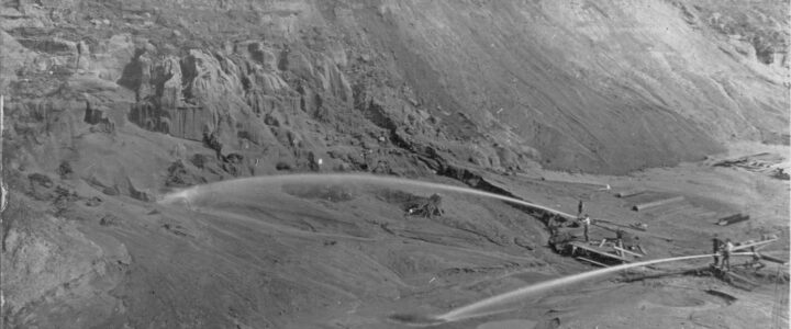
Why was Portland’s Mayor against the construction of “The Cut”?

Portland’s mayor Henry Lane’s strongly opposed giving SP&R a franchise in 1906. SP&R had opted to create a trench rather than a tunnel. Lane declared this proposal “a defacement of property and a visual blight [an] out-and-out give-away…destroy the unity of the neighborhood.” Portland City Council members overrode the Mayor’s veto. The Empire Maker, James J. Hill’s considerable influence and financial resources ultimately prevailed and the Spokane, Portland & Seattle Railway (SP&S) received the franchise.
A Deep Divide, A Looming Threat: How Railroad Greed Left St. Johns Vulnerable

Residents of St. Johns consider “The Cut” to be the neighborhood boundary; it is close to the historic boundary between the historic cities of St. Johns and Portland. The construction phase pre-dated the St. Johns Bridge (19310. All of the four original 1909 steel deck truss bridges over “The Cut” were designed by Ralph Modjeski. The bridges over Fessenden, Lombard and Willamette today are owned by Burlington Northern Railroad and replaced over a dozen surface streets that once flowed out of St. Johns. Egon Terplan, Regional Planning Director SPUR states in a documentary about Modjeski: “Our failure to maintain these bridges threatens our future.” Medjeski also designed the railway bridges on either end of the cut that cross the sloughs and the Columbia and Willamette Rivers.
Local lore in North Portland speaks of a deliberate divide, a chasm carved to isolate the then-independent City of St. Johns from the burgeoning city of Portland. However, the enduring geographic scars are the responsibility of the railroads, an industry whose relentless pursuit of progress historically overshadowed community well-being. The construction of “The Cut” an eighty foot deep ravine disrupted the evolving streetcar system, and funneled access on the peninsula onto four bridges spanning The Cut. The construction cost was a three-million-dollar project (equivalent to $74.46 million in 2025).
James J. Hill

This physical manifestation of ambition was largely the brainchild of railroad magnate James J. Hill, the driving force behind the Spokane, Portland & Seattle Railway (SP&S). Known as “the Empire Builder” by admirers – a man who famously opposed labor unions, stating they would cause “grave financial reverse”. The Cut offers a direct, level route to a vital railroad bridge, ensuring trains maintained speed, unhindered by natural topography or existing neighborhoods. The earth excavated filled critical riparian marshlands, reshaping the natural environment to serve the burgeoning rail infrastructure. The first train navigated “The Cut” on November 17, 1908. SP&S’s competition, the Oregon and Washington Railroad and Navigation Company, started operating on the one-mile long Peninsula Railroad Tunnel parallel to the cut in 1911. The City of Portland ordinance granting both companies franchises. “The Cut” with its massive excavation was notably unfavorable, lacking a construction time limit or a recall provision, potentially violating the City Charter’s common user requirement, and stipulating that the railroad would bear no costs beyond their own land investment and the replacement of existing streets with a mere four steel traffic bridges: N Willamette, N Lombard, N Fessenden (BNSF owned), and N Columbia (PBOT owned).
History’s Long Shadow

Today, this historical decision casts a long shadow. Where sixteen streets once seamlessly connected the St. Johns Peninsula, only four now remain, reliant on bridges to traverse the artificial ravine. The consequence of prioritizing railroad efficiency over community well-being is a looming crisis. Experts have determined that the four bridges spanning “The Cut” are highly vulnerable to collapse in a significant seismic event. This leaves the approximately 15,291 residents of the St. Johns Peninsula facing the terrifying prospect of being physically cut off.

Today’s Crisis
The current crisis reflects a century of perceived neglect. The community seeks a seismic upgrade of the Columbia Blvd bridge, managed by PBOT. Without it, the fate of North Portland Peninsula residents in even a mild quake is a gamble. Without a functioning bridge, families will be separated, and emergency access will be severed. An emergency route on Columbia Boulevard is imperative.


