
Were the Concrete Pads on NW 28th and Thurman the Footings of the 1905 Lewis & Clark Exposition Water Towers? The Final Verdict. (updated 8/18/2025 text rewritten for clarity as the pads are no longer)
History is a puzzle, and sometimes the most interesting discoveries are made when a piece doesn’t fit. For years, a small cluster of concrete pads at the corner of NW 28th and Thurman had sparked a persistent rumor among neighbors: were these the lost footings of the massive water towers from the 1905 Lewis & Clark Exposition? Indeed, it was a compelling theory, connecting a forgotten corner of the city to a landmark historical event.
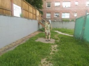
On our walking tours, we’re dedicated to uncovering the real stories behind the City’s landmarks. Therefore, when a construction fence went up around the vacant lot, we saw our last chance to play historical detective. We had to know the truth before this little piece of history was paved over.
The Problem with Pretty Maps
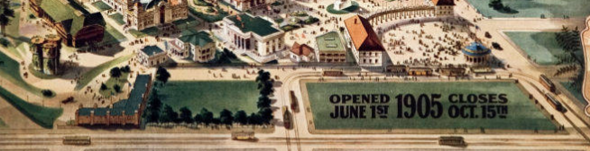
Unfortunately, the artistic rendering map of the 1905 “Lewis and Clark Centennial and American Pacific Exposition and Oriental Fair” created a false narrative. These maps, much like a modern-day subway map, were not intended to show accurate distances or true scale. They simply offered a directional guide for fair attendees. This lack of precise detail gave generations a poor sense of the fair’s true layout, a problem that grew worse after the Forestry Center burned down in 1964. With that official landmark gone, people no longer had a physical reference point to help them visualize the space, and the inaccurate maps compounded this loss of a sense of place.
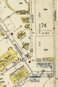
The breakthrough came with a deeper dive into the archives. When we consulted a detailed June 1905 Sanborn map, the answer became clear. The map showed that our exact location housed the western end of the Museum of Art (the “Fine Art Building”), not the water towers. The towers were located much farther north, in the middle of what is now the intersection of NW 28th and Upshur. The “souvenir map” had led us astray—a great example of why primary sources are so crucial.
Always seek out the owner
The real ending to this story, however, came directly from the source. We tracked down the former owners of the property, who finally revealed the true origin of the pads. Their response was simple and direct: “They were footings for a mixed-use building (commercial and residential) that we were going to build in the mid-1990s… there is no interesting historical story behind the vacant lot.” Pouring the cement simply kept the permit open.
Fun Facts that go deeper into actual elements of the the 1905 Fair:
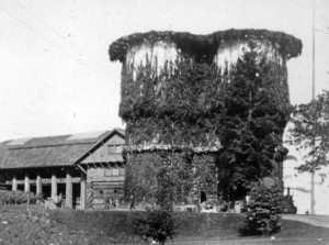
#73 Water Tower Moved to St. Johns
#76 Trixie The Horse
#30 The American Inn
Link to Carl Abbot’s wonderful post for the Oregon Encyclopedia about the Lewis and Clark Exposition.