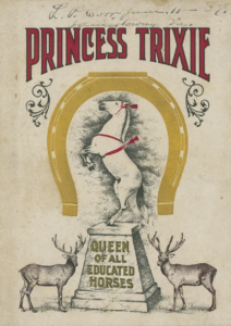
Answer Princes Trixie: Queen of all Educated Horses Autobiography: an accurate account of the sayings and doings of the wisest and most highly educated horse in the world. Free link to the entire book: Link to Book
Using cash register
Using a NCR Cash Register
chapter 1
Cover of Book Princess Trixie
Image from Book
Front Page of book
1904 by Waltermire Studio (Sioux City, IA)
Trixie playing music
News Paper
She worked for NCR
Image from book.
Crowds waiting to see Trixie
Map of Trail in Portland close up Trixie was sharing Space with diving elks
The animal autobiography as a genre is problematic. Princess Trixie: Autobiography: an Accurate Account of the Sayings and Doings of the Wisest and Most Highly Educated Horse in the World is an account of a Grey, ½ Arabian mare who worked internationally as vaudeville entertainer.
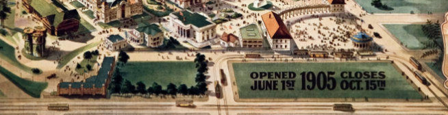
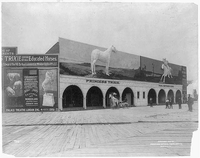
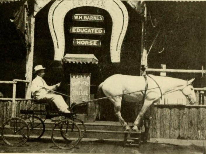
The first edition of the book was sold to her fans at the 1905 Lewis and Clark Exposition and Oriental Fair. Her initial repertoire of bowing, playing the chimes, and simple math grew along with her talents. Now that she was able to count and multiply she was used to market the cash register for National Cash Register Company by demonstrating making change and keeping accounts in check. She performed alongside the two diving elk in Portland. Trixi was an advocate for the humane treatment of animals and was an honorary member of humane societies. Her death in a train wreck was national news in 1909.
Question: To what city did the 1905 Lewis & Clark Exhibition water tower relocate?
Answer: St. Johns
Part One Of Reuse Repurpose, Ravage
My fascination with water towers was kindled during my Place Matter employment. One of the nominated locations was a PWA era public pool, in Harlem NYC. The local narrative iterated by elders was prior to the construction of the PWA pool was learning to swim in rooftop water towers prior to attempting river swims. I have since pestered friends of friends who habited in water towers converted into dwellings and hotels, as well as being drawn to fictional horror stories and researching water tower tragedies like the collapse of the West Bluff Water Tower in Peoria, Illinois. The 1905 Lewis & Clark Exhibition Water Tower was highlighted in Fun Fact #50 in 2019. It was years later that I encountered information that the water towers were relocated.
A Gallery Of Water Tower Images
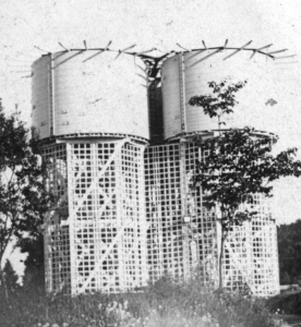
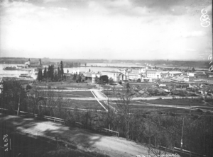
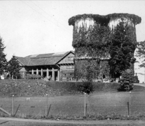
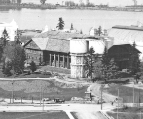
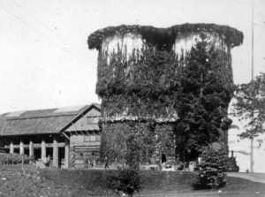
The first five are of the towers when they were next to the Forestry Building. The green space alien tower is the most recent replacement in St. Johns.
Courtesy Norman Gholston
Courtesy Norman Gholston
Courtesy Norman Gholston
Cropped Courtesy Norman Gholston
Courtesy Norman Gholston
Courtesy St. Johns Review image 2020
In the early 1900s city residents clamored for additional water towers to be built in downtowns as a tool for firefighters. Portland’s Fire Chief Campbell articulated to the press that many costly NW fires could have been avoided if there were more water towers. “Every large city has a water tower as part of the equipment of its fire department.” (9-14-1907 Oregonian p 10). Campbell died in the collapse of the Union Oil Plant building as a result of a fire in 1911. Chief David Campbell is honored along with 76 other Portland Firefighters at Fireman’s Park on SW 18th & Burnside.
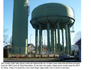
The original St Johns Water Tower in 1903 Courtesy St. Johns Review
The City of St. Johns like their neighbor Portland saw the need for additional water towers. Sy. Johns acquired the Lewis & Clark Fair Water Towers that were no longer required after the 400-acre fairgrounds closed on October 15. 1905. This post includes an image of the original towers in 1905 as well as an image of a greatly altered when the round towers were reassembled and added on to an existing rectangular tower. Cassandra Bird published an article for the St. Johns Review as well as the letter to the editor below advocating for preservation:
Although Portland prides itself on oddities, few things are keeping us weird these days. In St. Johns, a green water tower represents pride of place, and the city is trying to sell it. The city says the tank at North Willamette Boulevard and Oswego Street is on track to be “disposed of” because it is no longer “of use.” But it is used as a location marker, it shows our history, it is replicated on postcards, and it defines our skyline.
Oregonian Letter to the Editor 3-24-2021 by Cassondra Bird, Portland
Cropped image of Water Towers with Ivy Forestry Center in background on the left. Image Courtesy Norman Gholston
Were the Concrete Pads on NW 28th and Thurman the Footings of the 1905 Lewis & Clark Exposition Water Towers? The Final Verdict. (updated 8/18/2025 text rewritten for clarity as the pads are no longer)
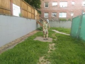
Image of Norman Gholston standing on top of one of the cement pads June 2019.
History is a puzzle, and sometimes the most interesting discoveries are made when a piece doesn’t fit. For years, a small cluster of concrete pads at the corner of NW 28th and Thurman had sparked a persistent rumor among neighbors: were these the lost footings of the massive water towers from the 1905 Lewis & Clark Exposition? Indeed, it was a compelling theory, connecting a forgotten corner of the city to a landmark historical event.
On our walking tours, we’re dedicated to uncovering the real stories behind the City’s landmarks. Therefore, when a construction fence went up around the vacant lot, we saw our last chance to play historical detective. We had to know the truth before this little piece of history was paved over.
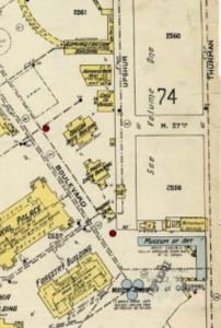
Zoom and cropped image from June 1905 Color Portland Sanborn Map
The Problem with Pretty Maps
Unfortunately, the artistic rendering map of the 1905 “Lewis and Clark Centennial and American Pacific Exposition and Oriental Fair” created a false narrative. These maps, much like a modern-day subway map, were not intended to show accurate distances or true scale. They simply offered a directional guide for fair attendees. This lack of precise detail gave generations a poor sense of the fair’s true layout, a problem that grew worse after the Forestry Center burned down in 1964. With that official landmark gone, people no longer had a physical reference point to help them visualize the space, and the inaccurate maps compounded this loss of a sense of place.
The breakthrough came with a deeper dive into the archives. When we consulted a detailed June 1905 Sanborn map, the answer became clear. The map showed that our exact location housed the western end of the Museum of Art (the “Fine Art Building”), not the water towers. The towers were located much farther north, in the middle of what is now the intersection of NW 28th and Upshur. The “souvenir map” had led us astray—a great example of why primary sources are so crucial.
Always seek out the owner
The real ending to this story, however, came directly from the source. We tracked down the former owners of the property, who finally revealed the true origin of the pads. Their response was simple and direct: “They were footings for a mixed-use building (commercial and residential) that we were going to build in the mid-1990s… there is no interesting historical story behind the vacant lot.” Pouring the cement simply kept the permit open.
Marketing Materials lead us astray, but it was a fun history hunt.
Fun Facts that go deeper into actual elements of the the 1905 Fair:


")